
Home / Attractions / Karst geology
Two hundred and fifty million years ago you would have been underwater here, and something with flippers would have been swimming past your head. This is how that became a rice paddy.
The rock that makes these peaks is Triassic — laid down very roughly 250 to 200 million years ago, when this part of what is now Guizhou lay under a warm shallow sea. Limestone is mostly the accumulated remains of marine life and precipitated carbonate: shells, skeletons, mud, compressed over an unimaginable span into stone.
So the material of the peaks is, in a real sense, biological. The valley is built out of the bodies of things that lived in a tropical ocean.
We know this in an unusually direct way, because the animals are still here.
In 1957, fossils of a small marine reptile were found near Xingyi. It became known as the Guizhou Dragon (贵州龙) — and is reported as the first marine reptile fossil discovered in China. It belongs to what palaeontologists call the Xingyi fauna: an assemblage of Triassic marine life preserved in the rock around this city.
At the geological park museum in Wusha, west of Xingyi, there is a 5.2-metre ichthyosaur — a large marine reptile — still embedded in the slab it was found in.
Tectonic uplift lifted the old seabed into the air. Limestone has an unusual property: it dissolves. Rainwater picks up carbon dioxide from the air and the soil, becomes weakly acidic, and slowly takes the rock apart along its cracks and bedding planes.
Given enough rain, enough time and thick enough limestone — which is exactly what this corner of China has — the result is karst: a landscape shaped less by carving than by removal. What is left standing is what the water didn't take.
That's also why karst country is full of things that aren't there: caves, sinkholes, dolines, disappearing streams, underground rivers. The Xingyi geopark's inventory includes all of them.
If you've seen Guilin or Yangshuo, you've seen the same chemistry produce a different result: there, sheer-sided towers; here, rounder cones. Chinese geographers have long distinguished two arrangements, and the terms are used internationally because no European language had good equivalents:
The difference comes down to water — how near the surface the water table sat while the landscape was being dissolved out. And the two aren't fixed categories: given long enough, and enough sediment filling in around their feet, clustered peaks can be undercut until they stand alone. This valley has both kinds, sometimes within sight of each other.
One thing worth clearing up: the name Wanfenglin — "forest of ten thousand peaks" — is centuries older than any of this terminology. It's a description someone gave the view, not a geological classification. Pleasingly, it happens to fit.
Where to go next. If the question of who has lived on this valley floor interests you more than how it formed, that has its own story and it is not a comfortable one: the city's name commemorates the defeat of an uprising by the people farming here. Everything we've used across these pages is listed, with the free sources linked, on our sources page.
Almost every English page about Wanfenglin quotes the Ming traveller Xu Xiake (徐霞客, 1587–1641) saying something to the effect that of all the mountains under heaven, only here do peaks form a forest. It is a good line. He does not appear to have written it.
The couplet is absent from his travel diaries, and the Chinese sources that repeat it — including provincial media — hedge it with xiangchuan (相传), "it is said." It also reads wrong: a tidy seven-character couplet, where Xu Xiake wrote terse diary prose.
What he did write is better, because it is an observation rather than a compliment. He reached Huangcaoba — the old name for Xingyi — in the autumn of 1638, having walked through Guangxi and Yunnan first, and set the three landscapes against each other:
The mountains of western Guangxi — some bare rock, some part rock — each stands apart on its own line, unmixed with the others. The mountains of southern Yunnan are earthen peaks winding about, with rock showing here and there, and not in one case out of ten. The mountains of southern Guizhou fall between the two, and are remarkable for this alone: they crowd together, and they stand sheer.
徐霞客《滇游日记二·黄草坝札记》, dated to 1638. Our translation. The passage is in the received text of the Xu Xiake Youji; we have checked it against two independent full-text editions.
That is a real piece of comparative geomorphology, made on foot, three hundred years before anyone used the word fenglin. And it happens to answer the question most visitors actually arrive with — how is this different from Yangshuo? Xu Xiake's answer, standing where you'll be standing: Guangxi's peaks stand apart from one another; these ones crowd.
A second line of his is quoted even more often — that these clustered peaks are the marvel of the southwest. That one is genuine, but he wrote it in Yunnan about the whole karst belt running for thousands of li, not about this valley in particular. Xingyi sits at its southwestern end. We'd rather tell you that than let you think a famous man was describing your view.
Here is the part that turns geology into human geography, and it's the thing we'd most like visitors to notice.
In fenglin country the peaks are separated by a flat, sediment-filled plain — the very process that isolates the hills is the process that builds the floor between them. That floor is level, it holds water, and it has soil.
In a province where an old saying complains that there is not three feet of level ground, a wide flat valley floor is not scenery. It is the only place you can grow rice.
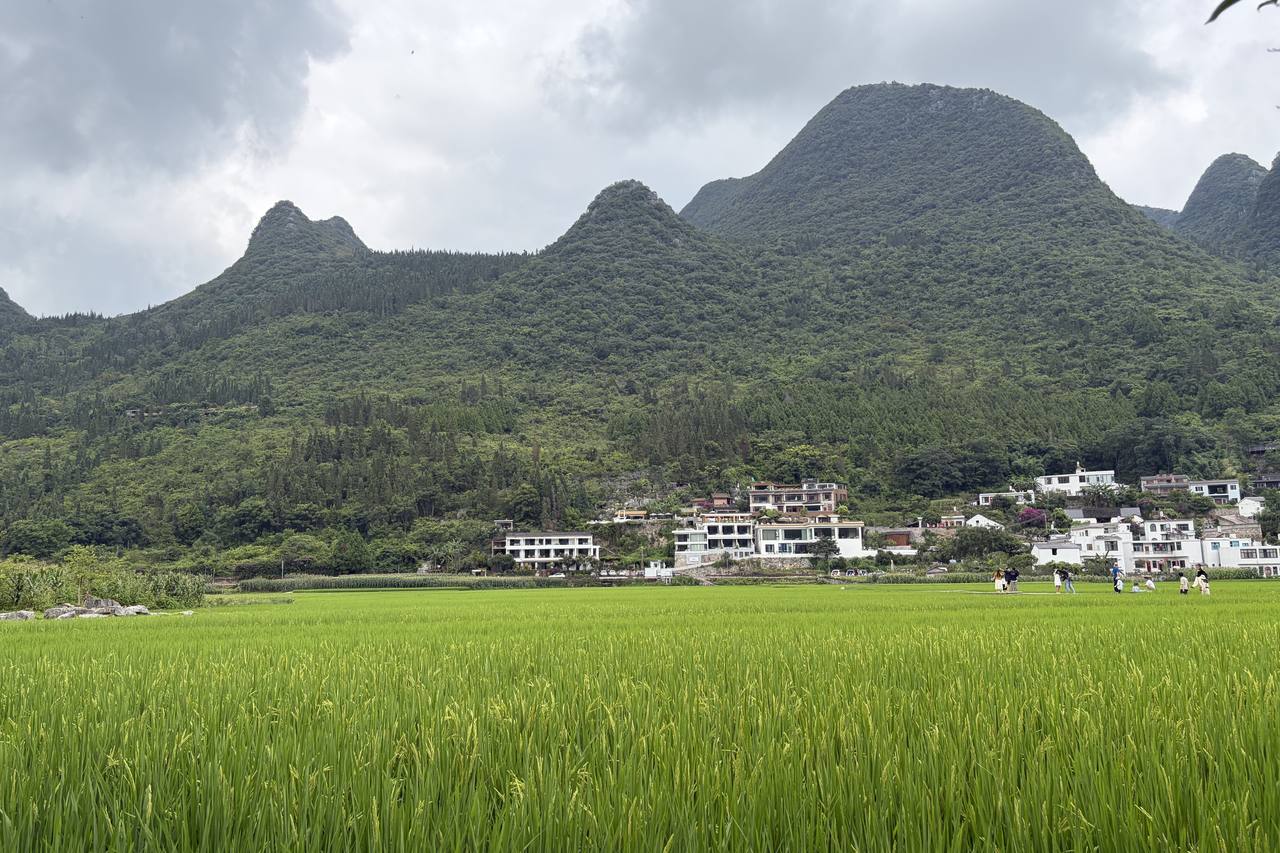
The villages between the peaks are largely Bouyei (布依族, also written Buyi) — the largest ethnic group in this prefecture, which is formally the Qianxinan Buyei and Miao Autonomous Prefecture.
The Bouyei language is not a dialect of Chinese. It belongs to the Tai-Kadai family (also called Kra-Dai), in the Northern Tai branch — which means that, linguistically, it is a relative of Thai and Lao, and very close to Zhuang, the language of neighbouring Guangxi. The similarity with Zhuang is so strong that some linguists treat them as one entity, called Bouyei in Guizhou and Zhuang in Guangxi.
Their ancestry is traced to the ancient Baiyue peoples of southern China, with a presence in this region going back more than two thousand years; the Bouyei and Zhuang are generally described as having become distinct groups around the tenth century. About 97% of China's Bouyei population lives in Guizhou.
But set your expectations honestly, because most travel writing about this region won't. Bouyei identity here is a matter of ancestry and registration more than of visible difference: daily life in these villages looks much like rural Han China, traditional dress is not everyday wear, and Mandarin does the work of conversation. Assimilation has gone a long way.
That's a less exotic story than the one usually sold, and we think a more interesting one. The people farming this valley descend from a language world that reaches to Thailand and Laos, and have worked this particular flat ground for a very long time — and you would not necessarily know it to look at them. We'd rather tell you that than promise you a costume.
Karst country famously loses its water underground — limestone regions are often dry despite heavy rain. So how this valley holds enough surface water to grow wet rice is a genuinely good question, and we don't have a properly sourced answer yet. Same with the Bagua Field: everyone explains its circular shape by the eight trigrams, but whether it began as a natural depression or a deliberate layout, we haven't established.
We'd rather leave those open than invent something tidy. If you know this ground better than we do — geologists and geographers do read pages like this — tell us. We'd rather be right than look right.
| Status | |
|---|---|
| Xingyi UNESCO Global Geopark | ✅ Yes. Designated 27 March 2024 by UNESCO's Executive Board — Guizhou's second, after Zhijin Cave |
| South China Karst World Heritage | ❌ No. That property has seven clusters — Shilin, Libo, Wulong, Guilin, Shibing, Jinfoshan and Huanjiang. Wanfenglin is not one of them |
We spell this out because the two get mixed up constantly, including by visitors writing reviews. Global Geopark and World Heritage are different UNESCO programmes with different criteria. Xingyi holds the first, not the second — which is still a serious designation and one almost no English-language source about this city mentions.
Where this comes from: UNESCO documentation for the South China Karst property and the March 2024 Xingyi Global Geopark designation, published work on fenglin and fengcong, and Chinese geopark and prefecture sources for the Xingyi fauna. Where we couldn't verify something, we've said so rather than smoothing it over.