
Home / Wanfenglin
One of China's clearest cone-karst landscapes — an entire horizon of green stone peaks, farmed and lived in for centuries. Here's everything you need to visit it independently.
Wanfenglin (万峰林, "Ten Thousand Peaks Forest") is a belt of nearly 20,000 cone-shaped karst peaks stretching across the south of Xingyi, Guizhou. UNESCO, which made the surrounding area a Global Geopark in March 2024, counts more than 20,000 karst peaks here. We've written up how it formed — including what the peaks were doing 250 million years ago.
A note on two things you'll read elsewhere. Chinese tourism copy often calls this "the world's most typical cone karst" or "a museum of cone karst." We've looked for a source behind those phrases and can't find one — no named scientist, no paper, no document. They appear to be marketing language, so we don't repeat them. Separately, the couplet about ten thousand peaks widely attributed to the traveller Xu Xiake is not in his diaries; Chinese sources that quote it hedge with xiangchuan — "it is said." What he actually wrote is more interesting, and we quote it there.
What makes it different from other famous karst areas — Yangshuo, say — is that it's a living landscape almost untouched by mass tourism. Between the peaks are rice paddies, canola fields and villages that have farmed this land for centuries — this is a Bouyei autonomous prefecture, though day-to-day life here looks much like rural China anywhere. You can cycle through it on quiet lanes for hours and meet more farmers than tourists.
| Official shuttle route | Open valley lanes | |
|---|---|---|
| Cost | Admission, plus a separate fare for the sightseeing bus. Visitors have reported paying roughly ¥60–85 to enter and about ¥50 more for the bus | Nothing |
| What you get | The visitor centre, and a hop-on-hop-off bus around the West Wanfenglin viewing platforms — panoramic views from above, very little walking | The valley floor itself: lanes between the fields, the villages, people farming |
| Good for | Limited time, limited mobility, or if you want the classic top-down panorama | Anyone who'd rather be in the landscape than looking down at it |
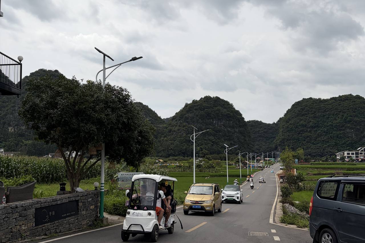
The two are not rivals; they are different experiences of the same landscape. The shuttle gives you the elevated panoramas with very little walking. The lanes give you the villages, the rice fields, the cafés and the dye workshops, at whatever pace you ride or walk. Plenty of visitors with a full day do both.
The ridge road (观峰道) runs along the hillside above the valley and strings together six viewpoints — General Peak (将军峰), Brocade Fields (锦绣田园), the Bagua Field (八卦田), Liuliu Dashun Peak (六六大顺峰), Bubu Gaosheng (步步高升) and the Fu-character Field (福字田). The thing most visitors do not realise: you cannot walk, cycle or drive it. The shuttle bus is the only way along it, which is what the fare is for. The full loop takes around four hours.
The valley road runs along the floor, through the three Nahui villages — Shang Nahui (上纳灰), Zhong Nahui (中纳灰) and Xia Nahui (下纳灰), the last of which is where most of the valley's guesthouses are. It is an ordinary public road. Bicycles and electric buggies hire out along it. No ticket is needed for the valley lanes; the ticket applies to the shuttle route and the footpath.
There is also a footpath from the same checkpoint up to Lingyun Peak (凌云峰), the highest point in the scenic area — about 4 km and two hours on foot, and ticketed like the ridge road.
The real-name reservation applies only to the ticketed route — not the valley road. Those tickets (the shuttle route and the Lingyun Peak footpath) are sold through a Chinese mini-programme with real-name registration, a passport or ID, and a timed entry slot. The valley road on the floor needs none of that — no booking, no ID, no gate — so the official notice that you "must book in advance" does not apply to it. Drones are not permitted anywhere in the scenic area.
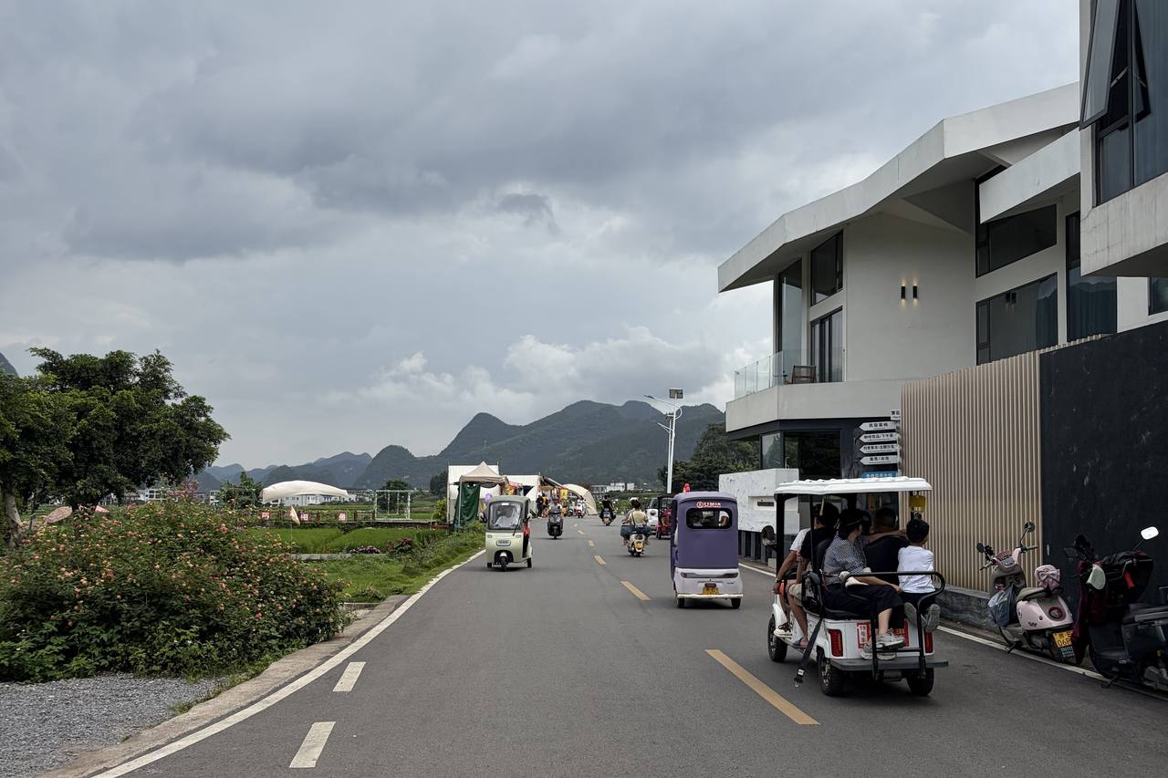
There is no fixed cycling route. Ride public roads and village lanes at your own pace, stopping for the peaks, rice fields, photos, small shops or a café. The valley floor is mostly gentle, but road surfaces vary and the main road is shared with cars; it can be congested during holidays. Use a current navigation map on your phone, follow local signs and keep out of working fields and private lanes. Bring drinking water. Food, drinks and any optional activities along the way are paid separately.
Hire places run along the valley road. Many visitors choose an electric buggy — a small four- or six-seat cart — so the family can travel together and stop when they like. Bicycles and e-bikes are available too if you would rather pedal.
Riding with a small child is genuinely possible here, which is not something you can take for granted in China. We have seen the kit ourselves: adult mountain bikes fitted with proper rear-mounted child seats — moulded shell, high back, full harness, footrests — and child-size helmets to go with them. As a rough guide, two bikes, three helmets and a child seat came to about ¥120 for the day when we last checked, in July 2026. In high season the bikes with child seats do get taken, so it is worth having one held. Full detail for families is on visiting Xingyi with a baby or toddler.
If the Chinese-only side of it puts you off, that is the part we can take off your hands — we drive you out, sort the hire, and then leave you to ride the valley on your own.
The official shuttle makes a loop of the main viewpoints (General Peak, the Eight Diagrams fields and others) with hop-on-hop-off stops. Fine if you're short on time or travelling with people who don't ride.
Trails and ridge paths give you the elevated views the buses can't reach. A moderate day-hike through the peak forest and villages is the photographer's choice — especially at sunrise, when mist pools between the cones. The marked route from the ticket checkpoint up to Lingyun Peak is about 4 km and two hours, and needs a ticket.
| West Wanfenglin 西峰林 | East Wanfenglin 东峰林 | |
|---|---|---|
| Character | The classic postcard: viewing platforms above rice paddies and the famous field patterns | Quieter farmland, villages, and the cycling country |
| Best for | First visit, photography, the sightseeing bus loop | Cycling, slow travel, village life |
The valley changes colour completely through the year — see it season by season in our four-season photo essay.
Fuller month-by-month detail — including the Chinese holiday dates that decide how crowded the valley is — on when to come.
Two names are worth separating. Wanfenglin — "forest of ten thousand peaks" — is a description of the view, and an old one. Xingyi, the name of the city, is not old and is not a description. It was awarded in 1797 by the Jiaqing emperor after the Qing crushed a Bouyei uprising in this country, and it means, roughly, promoting righteousness. Before that the prefecture was called Nanlong.
That is a strange thing to find on a road sign, and almost no visitor is told it. We've written up the whole story — from the land dispute that caused the rising to the woman who led it.
For directions, use an up-to-date navigation map on your phone and check local access signs. The embedded map below is for orientation, not a prescribed cycling route.
Most people underestimate this valley and give it an afternoon. Our view — and we'd say the same over dinner — is that two nights in Xingyi is the sweet spot: a full unhurried day here, plus a half day at Maling River Canyon, with Wanfeng Lake if you have a third.
And if you're travelling between Yangshuo and Yunnan, Wanfenglin sits almost exactly on that line — see the route guide for why breaking the journey here is worth a few extra hours on the train.
Deciding between Guizhou's karst west and its village east? We lay out the choice in eastern vs western Guizhou.